Commemorating a Fateful Day & Magnolia’s Mouzon Map
Written by George McDaniel,
Director of Interpretation at Magnolia Plantation & Gardens

“By the rude bridge that arched the flood,
Their flag to April’s breeze unfurled,
Here once the embattled farmers stood,
And fired the shot heard round the world.”
-Ralph Waldo Emerson, “The Concord Hymn” (1837)
In the early morning hours of April 19, 1775, British troops advanced upon the Massachusetts town of Lexington with the goal of proceeding on to nearby Concord, where a cache of weapons and powder was held. Thomas Gage, the Royal Governor of Massachusetts, feared a rebellion and sought to stamp out any unrest before it erupted in violence. On that fateful April morning, however, shots rang out that set this nation upon a long and bloody course towards independence.
While the American Revolution began in the New England countryside, it was won in the South. Don Higginbotham, renowned historian of revolutionary America, illustrated this point in The Journal of Southern History, writing, “The two most exciting and decisive campaigns of the war unfolded in the South. The outcome there put the seal on American independence.” (1) One of these “decisive campaigns” took place across South Carolina and a key piece of intelligence for both sides during that campaign was a map of the region created by a South Carolinian named Henry Mouzon.

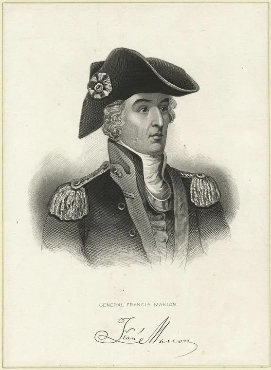
Mouzon’s map, an accurate map of North and South Carolina, with their Indian frontier, shewing in a distinct manner all the mountains, rivers, swamps, marshes, bays, creeks, harbours, sandbanks and soundings on the coasts; with the roads and Indian paths; as well as the boundary or provincial lines, the several townships, and other divisions of the land in both the provinces, indeed lived up to its detailed title. General George Washington carried a copy to survey what was happening in the South. The legendary Francis Marion utilized Mouzon’s work as he harassed the British army across South Carolina. In fact, Henry Mouzon served under Marion and fell critically wounded during the Battle of Black Mingo, not far from his home in Williamsburg County. On the other side, General Charles Cornwallis, with whom Marion sparred, used the map as he fought to subdue the rebellion in South Carolina while he chased Patriot forces across the state.
Published in May 1775 shortly after those infamous shots rang out at the Old North Bridge near Concord, Mouzon’s map remains an important artifact of the American Revolution, which began in earnest 250 years ago. The map’s astonishing detail reveals the world of the Carolinas during that pivotal period of history. Even today, the map remains an astounding achievement to behold. For that reason, Magnolia Plantation & Gardens is proud to have an original 250-year-old copy, one of only an estimated fifteen publicly known, as a featured piece in our collection. Passed down through generations, the map was carefully restored nearly ten years ago and still hangs prominently for all to admire as visitors enter the Magnolia House.
As a nation, we kick off the 250th anniversary of official hostilities commencing at Lexington and Concord. Let us all pause to reflect and honor the Minute Men who answered the call on that April morning 250 years ago. Further, let us remember that while the American Revolution declared independence and freedom, it was not freedom for all. It would take nearly another century and another far bloodier war for that flag to become unfurled. As we begin this journey, let us proceed with open minds and questions to learn about what the complex story of the American Revolution still might teach us today as the great historian Robert Middlekauff concluded in his epic tome, The Glorious Cause, writing, “In the years following independence, the Revolution released—or inspired—an enormous display of creative imagination. The Constitution was its finest expression, a profoundly original creation…as it drew upon the American and, let it be clearly recognized, the British past. It represented for its makers the ultimate defense of liberty.” (2) As we look forward in the coming years, let us also draw upon the past to map our path forward just as Mouzon’s famous map charted the course of liberty during the American Revolution.
If you’d like to read more about the American Revolution, here are some recommendations for further reading:
Borick, Carl. A Gallant Defense: The Siege of Charleston, 1780. Columbia: University of South Carolina Press, 2003.
Edgar, Walter. Partisans and Redcoats: The Southern Conflict That Turned the Tide of the American Revolution. New York: HarperCollins Publishing, 2001.
Ellis, Joseph J. The Cause: The American Revolution and Its Discontents. New York: W. W. Norton & Co., 2021.
Gordon, John W. South Carolina and the American Revolution: A Battlefield History. Columbia: University of South Carolina Press, 2003.
Middlekauff, Robert. The Glorious Cause: The American Revolution, 1763-1789. Oxford: Oxford University Press, 2005.
Rankin, Hugh F. Francis Marion: The Swamp Fox. New York: Thomas Y. Crowell Company, 1973.
Pancake, John S. This Destructive War: The British Campaign in the Carolinas, 1780-1782. Tuscaloosa: University of Alabama Press, 2003.
Wilson, David K. The Southern Strategy: Britain’s Conquest of South Carolina and Georgia, 1775-1780. Columbia: University of South Carolina Press, 2005.
(1) Don Higginbotham, “Some Reflections on the South in the American Revolution,” The Journal of Southern History 73, no. 3 (August 2007): 669.
(2) Robert Middlekauff, The Glorious Cause: The American Revolution, 1763-1789 (Oxford: Oxford University Press, 2005), 686-687.